Two new training opportunities on Winter Weather are being offered by NWS Raleigh! For clickable links to register, please visit www.weather.gov/rah/skywarn
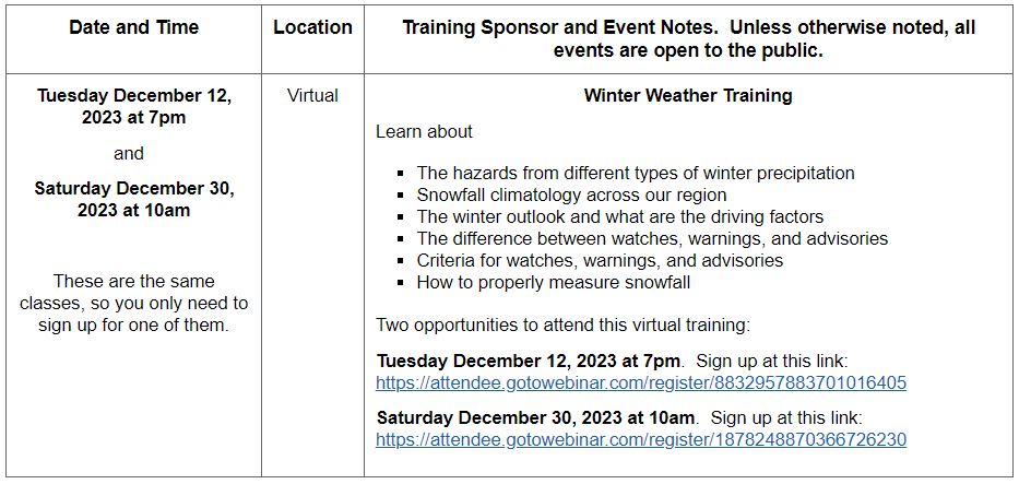
Two new training opportunities on Winter Weather are being offered by NWS Raleigh! For clickable links to register, please visit www.weather.gov/rah/skywarn
SKYWARN Spotters get ready! SKYWARN Recognition Day 2023 officially takes place Saturday, December 2, from 0000-2400 UTC. During this 24-hour period, SKYWARN operators and NWS offices will contact other radio operators across the world.
This annual event was originally developed in 1999 by the National Weather Service and the American Radio Relay League to celebrate the contributions that SKYWARN™ amateur radio volunteers make to the NWS mission of protecting life and property. Amateur radio operators also provide vital communication between the NWS and emergency management when normal communications become inoperative.
Central Carolina SKYWARN and the Raleigh National Weather Service, operating under the call sign WX4NC, will join in the fun on Friday night (December 1) from 7:00 PM to 11:00 PM and Saturday from 9:00 AM to 5:00 PM, making contacts on the K4ITL 145.210 repeater, WB4TQD 146.88 repeater, the K4ITL 147.105 repeater, the K4ITL 147.135 repeater, the Carolina 440 UHF Link System, IRLP (AllStar Node 28848 from 1600-1700 UTC), and HF (SSB & FT8). We will rotate through the repeaters so listen for us. To find the specific HF frequencies at any time, look for WX4NC on http://dxsummit.fi/#/.
We will also make contacts via Winlink this year; our Winlink address is WX4NC@winlink.org. Please use the Local Weather Report template under Mapping-GIS Forms. If you are not familiar with this form, you may send a regular message via Winlink.
Radio operators will exchange names, call signs, locations, signal reports, and a 1 or 2-word weather report such as “windy”, “sunny”, or the current temperature.
If you wish to register for this event, please visit https://www.weather.gov/crh/skywarnrecognition. However, we still want your contact even if you do not register! You may also spot yourself on a map.
There will be a special event certificate from the National Weather Service! Certificates will be electronic and printable from https://www.weather.gov/crh/skywarncert.
For further details on operating procedures and log submissions, please visit https://www.weather.gov/crh/skywarn_operating_procedures.
Hope to get you in the log!
SKYWARN Spotters get ready! SKYWARN Recognition Day 2022 officially takes place Saturday, December 3, from 0000-2400 UTC. During this 24-hour period, SKYWARN operators and NWS offices will contact other radio operators across the world.
This annual event was originally developed in 1999 by the National Weather Service and the American Radio Relay League to celebrate the contributions that SKYWARN™ amateur radio volunteers make to the NWS mission of protecting life and property. Amateur radio operators also provide vital communication between the NWS and emergency management when normal communications become inoperative.
Central Carolina SKYWARN and the Raleigh National Weather Service, operating under the call sign WX4NC, will join in the fun on Friday night (December 2) from 7:00 PM to 11:00 PM and Saturday from 9:00 AM to 5:00 PM, making contacts on the K4ITL 145.210 repeater, WB4TQD 146.88 repeater, the K4ITL 147.105 repeater, the K4ITL 147.135 repeater, the W4BAD linked system, the Carolina 440 UHF Link System, IRLP, and HF (SSB & FT8). We will rotate through the repeaters so listen for us. To find the specific HF frequencies at any time, look for WX4NC on http://dxsummit.fi/#/.
We will also make contacts via Winlink this year; our Winlink address is WX4NC@winlink.org. Please use the Local Weather Report template under Mapping-GIS Forms.
Radio operators will exchange names, call signs, locations, signal reports, and a 1 or 2-word weather report such as “windy”, “sunny”, or the current temperature and SRD Number if the station has one.
If you wish to register for this event and receive a spotter SRD event number, please visit https://www.weather.gov/crh/skywarnrecognition. However, we still want your contact even if you do not register!
There will be a special event certificate from the National Weather Service! Certificates will be electronic and printable from https://www.weather.gov/crh/skywarncert.
For further details on operating procedures and log submissions, please visit https://www.weather.gov/crh/skywarn_operating_procedures. Hope to get you in the log!
The Raleigh National Weather Service has directed Central Carolina SKYWARN to activate a Winter Weather Net at 9:00 AM on the 145.210 repeater on Saturday, January 19, to collect measured snowfall accumulation totals.
Spotter reports should include the following:
*Callsign and name
*Location – Street/Cross street, city & county or lat/long.
*Measured snowfall accumulation and time of measurement.
Spotters may also make reports on the Central Carolina SKYWARN Facebook page. You do not have to be an amateur radio operator to post a report on our Facebook page. All reports are very much appreciated!
Thank you and stay warm!
Weather Spotters get ready! SKYWARN Recognition Day 2021 officially takes place Saturday, December 4, from 0000-2400 UTC. During this 24-hour period, SKYWARN operators and NWS offices will contact other radio operators across the world.
This annual event was originally developed in 1999 by the National Weather Service and the American Radio Relay League to celebrate the contributions that SKYWARN™ amateur radio volunteers make to the NWS mission of protecting life and property. Amateur radio operators also provide vital communication between the NWS and emergency management when normal communications become inoperative.
Central Carolina SKYWARN and the Raleigh National Weather Service, operating under the call sign WX4NC, will join in the fun on Friday night (December 3) from 7:00 PM to 11:00 PM and Saturday from 9:00 AM to 5:00 PM, making contacts on the K4ITL 145.210 repeater, WB4TQD 146.88 repeater, the K4ITL 147.105 repeater, the K4ITL 147.135 repeater, the Carolina 440 UHF Link System, the W4BAD linked system, IRLP, and HF (80, 40, 30, 20, 15, and 10 meters SSB & FT8). We will rotate through the repeaters so listen for us. To find the specific HF frequencies at any time, look for WX4NC on http://dxsummit.fi/#/.
Radio operators will exchange names, call signs, locations, signal reports, and a 1 or 2-word weather report such as “windy”, “sunny”, or the current temperature.
If you wish to register for this event and receive a spotter SRD event number, please visit https://www.weather.gov/crh/skywarnrecognition. However, we still want your contact even if you do not register!
There will be a special event certificate from the National Weather Service! Certificates will be electronic and printable from https://www.weather.gov/crh/skywarnrecognition.
Due to Covid-19, the Raleigh NWS will be unable to accommodate visitors to its facility for tours this year.
Hope to get you in the log!
Basic SKYWARN Spotter Training is being offered Thursday, March, 2021, at 7:00PM. This is a a 90 minute online webinar open to the public and taught by the Raleigh National Weather Service. The register for the course, please click on the following link: https://attendee.gotowebinar.com/register/825438387712453388
North Carolina’s annual statewide tornado drill for 2021 will take place on Wednesday, March 10, at 9:30 AM EST. Every school, business, work place, and family across the state is strongly encouraged to participate in the statewide tornado drill.
Here are some key points to remember about the drill:
The Raleigh National Weather Service is offering two virtual Basic SKYWARN Spotter Training classes. One is Tuesday, February 16, at 6:00 PM, and the other is Wednesday, February 24, at 2:00 PM. Both are 90-minute classes. Both are open to the public. Registration is required.If you have never had spotter training, consider taking one of these classes.
Spotter certification is good for 3 years; at the end of 3 years, you will need to renew your certification.
For more details about these classes, please visit www.weather.gov/raleigh/skywarn
 Users Today : 3
 Users Yesterday : 4
 Users Last 7 days : 31
 Users Last 30 days : 176
 Users This Month : 151
 Users This Year : 1240
 Total Users : 7960
 Views Today : 6
 Views Yesterday : 10
 Views Last 7 days : 75
 Views Last 30 days : 361
 Views This Month : 324
 Views This Year : 8082
 Total views : 22344
 Who's Online : 0 Your IP Address : 3.143.204.241 Server Time : 2024-07-27