Now is the time to start preparing in the event that Hurricane Matthew affects our area. Check out these preparedness tips, and find more at weather.gov/hurricanesafety. Please share these tips with friends and family.
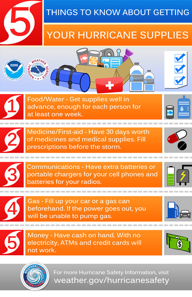
Now is the time to start preparing in the event that Hurricane Matthew affects our area. Check out these preparedness tips, and find more at weather.gov/hurricanesafety. Please share these tips with friends and family.
Events like the recent flooding in Louisiana, Hurricane Hermine approaching Florida, and Hurricane Lester in the Gulf remind us that weather can change at a moment’s notice.
Disasters don’t always occur when we are together with our family and friends, and so it’s important to take time now to plan what you will do in an emergency. It only takes a few minutes to talk through the greatest risks that can affect where you live, work or go to school.
This September and throughout the year here are few actions you can take to get started:
For more information, please visit https://content.govdelivery.com/accounts/USDHSRC/bulletins/1611da5
Mid-August through mid-October represents the peak of hurricane season in the Atlantic basin. When there is tropical cyclone activity, please visit our Central Carolina SKYWARN Facebook for updates. We post frequently! During other times, you’ll find other items of interest. That website URL is https://www.facebook.com/CentralCarolinaSKYWARN/
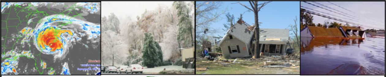
As the days get shorter and temperatures fall, a new round of weather hazards are on the rise. This transitional season often features weather hazards seen during both warm and cold months, including hurricanes, wildfires, intense winds, flooding, droughts, early season snow and more.
Here’s what you need to know to stay safe this fall! Get ready for fall weather with preparedness tips from the National Weather Service. www.nws.noaa.gov/com/weatherreadynation/fall_safety.html
![]()
Central Carolina SKYWARN is now a NOAA Weather-Ready Nation Ambassador! WRN Ambassadors are formally recognized by NOAA as organizations committed to collaborating with NOAA, sharing preparedness messaging in outreach to the public, and serving as examples themselves by implementing resilience best practices. For more information as Weather-Ready Nation Ambassadors, please visit http://www.nws.noaa.gov/com/weatherreadynation/
We will be posting WRN safety messages from time to time to help folks prepare for extreme weather!
Please join us on the Central Carolina SKYWARN Information Net every Tuesday night on the 146.88 repeater at 9:15 pm. Hear the weekly weather impact briefing delivered by a staff member of the Raleigh National Weather Service. The pdf of the briefing can be downloaded from www.centralcarolinaskywarn.net. Folks may also listen via www.broadcastify.net; visit that website and click in sequence on LIve > North Carolina > Wake County. Central Carolina SKYWARN.
Get your calendars out! The Advanced SKYWARN class is offered only once-per-year in the NWS Raleigh/Central Carolina SKYWARN coverage area and has been scheduled for Tuesday, Sept. 6, from 7:30pm-9pm at North Carolina State University, Jordan Hall room 1216. The street address is 2800 Faucette Dr, Raleigh, NC 27695.
A Basic SKYWARN Spotter class will be offered earlier on Tuesday, Sept. 6, from 6:00pm-7:30pm, at the same location.
These SKYWARN Spotter Classes are sponsored by the NCSU Student Chapter of the American Meteorological Society
There is no cost to attend. Pre-registration is not required. Simply show up.
Hope to see you there!
SKYWARN Spotter Training will be offered on the CCS Information Net on March 29 & April 5at 9:15 PM on the 146.88 repeater.
This training may used to earn initial spotter certification or renew certification which is required every three years.
Part 1 of Basic Training will be March 29 ; Part 2, April 5. The instructor will be Nick Petro WX3H, Warning Coordination Meteorologist with the Raleigh National Weather Service.
To fully benefit from this training and to receive certification, you must:
A. download the training presentation before each net from www.centralcarolinaskywarn.net (It will be included with the Weekly Weather Impact Briefing. Click on the Weekly Weather Impact Briefing on the top menu to download.)
B. listen and check in at the end of both nets, and
C. email CCS Emergency Coordinator Virginia Enzor at nc4va@nc.rr.com with your name, call sign (if licensed), and preferred email address. The NWS will then contact you about completing the spotter certification process.
Scanner listeners and listeners receiving live streaming audio on the internet at www.broadcastify.com may also participate by downloading the presentations and emailing Virginia Enzor at nc4va@nc.rr.com immediately after both nets. Again, be sure to include your name, call sign (if licensed), and preferred email address.
Again, you must listen both night to complete the training.
Central Carolina SKYWARN (CCS) will activate for this event per the direction of the Raleigh National Weather Service. We will activate on the 146.88 repeater beginning at 6:00 AM on Monday and conduct formal nets at the top of each hour until the National Weather Service directs us to stand down. We will monitor in between nets for any changeovers in precipitation.
Spotter reports should include the following information:
Folks may make reports via the SKYWARN net, or post here on the Central Carolina SKYWARN Facebook page.
The SKYWARN Net may also be monitored via live-streamed audio at www.broadcastify.com .
We appreciate your reports. Stay safe!
 Users Today : 20
 Users Yesterday : 19
 Users Last 7 days : 122
 Users Last 30 days : 298
 Users This Month : 248
 Users This Year : 2254
 Total Users : 11536
 Views Today : 20
 Views Yesterday : 33
 Views Last 7 days : 142
 Views Last 30 days : 359
 Views This Month : 294
 Views This Year : 3803
 Total views : 29280
 Who's Online : 0 Your IP Address : 216.73.216.32 Server Time : 2025-10-25